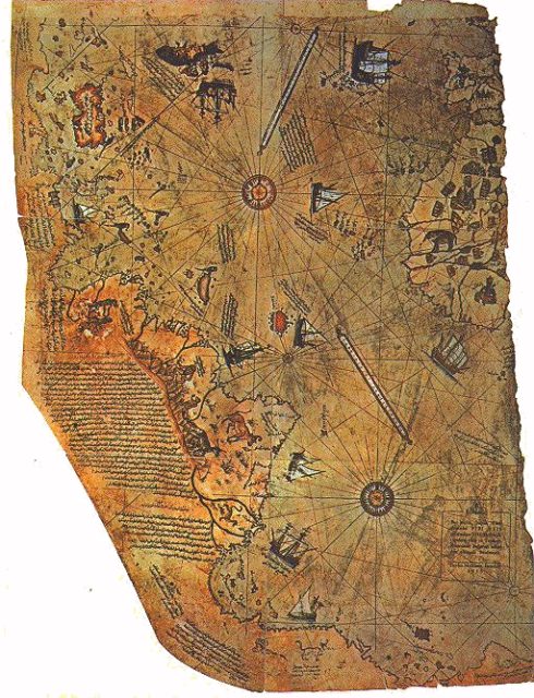
The Piri Reis Map was a map drawn on gazelle skin parchment and based on about 20 other maps, some by Christopher Columbus.
James Cook, in 1773 passed the Antarctic circle for the first time. This is documented officially as the first time this land was discovered. However, a map that was found in 1929 counters this claim.
This map was originally discovered in Istanbul, Turkey. Gustav Deissmann, a German theologian was arranging the contents of Istanbul’s Topaki Palace’s library alongside the palace director when they stumbled on some maps and charts among piles of overlooked materials.
They eventually identified it as the Piri Reis map, after the medieval cartographer Piri Reis, who signed the bottom. What stood out was the fact that alongside the usual land masses was Antarctica which had seemingly been discovered just 200 years earlier.
Gustav Deissmann was puzzled that the continent was on a map from 1513. After Piri Reis created this map in 1513, he named it the map of the world. In 1517, he offered the map to the Ottoman Sultan Selim I, alongside other maps and charts.
The Sultan considered it one of the MOST complete maps in the world because it was not based on the singular effort of Piri Reis. The map measured approximately 35 by 24 inches.
While it’s in pieces, the surviving bits show the map of the world. This interesting reveal of the ice continent can be seen in the bottom section. Almost all historians argue that the continent was discovered in 1773. The continent on the map wasn’t covered in snow as we know it to be now.
Captain Lorenzo W. Burroughs, a U.S. Air Force captain who also happens to be a historian has argued that the depiction of Antarctica on the Piri Reis Map matches what we know it to be aside from the snow.
The Real Pinocchio Story Was Horrific, Unlike Disney Portrayal

