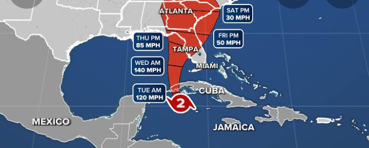

As the storm barreled toward Florida, water levels off Cuba’s west coast were predicted to climb by as much as 14 feet. On Wednesday, Tampa might sustain a direct hit.
Early on Tuesday morning, as Hurricane Ian made landfall in western Cuba, it intensified into a strong Category 3 hurricane, according to U.S. officials.
The National Hurricane Center reported maximum sustained winds of 125 mph just southwest of the town of La Coloma in the Pinar Del Ro province at around 4:30 a.m. ET, according to an early Tuesday morning update.
The governor of Florida, Ron DeSantis, proclaimed a state of emergency after warning that Ian may strike as a powerful Category 4 hurricane with winds of up to 130 mph. Tampa Bay is anticipated to receive a direct impact as soon as Wednesday
DeSantis predicted that there would be a significant storm surge as a result. “Flooding incidents are going to occur. There will be many various effects on you.
Prior to the storm’s arrival this week, officials dispatched emergency and medical staff, forcing hundreds of thousands of residents in Pinar del Ro to leave.
According to the AP, locals in Havana, two hours to the east, expressed concern about potential floods as city workers cleared out clogged storm drains and fishermen hauled out their boats.
Abel Rodrigues, 54, told the AP, “I pray we avoid this one because it would be the last of us.” “We have so little already.”
Ian passed through the adjacent Cayman Islands earlier on Monday, but no significant damage was noted. Premier Wayne Panton said the British territory was “very fortunate to have been spared the worst of a potentially very serious storm” after emergency officials announced the “all clear” at 3 p.m. local time.
Oil companies evacuated employees from deepwater facilities in the Gulf of Mexico as the hurricane approached Florida; Tampa and Pinellas County airports announced Tuesday closures; American Airlines provided travel waivers for passengers flying into or out of 20 airports in Florida and the Caribbean.